InDiD
Description
InDiD is a pilot project aiming to evaluate how connected infrastructures will bring enhanced perception to road users. With a mix of use cases and wide inclusion of pilot sites, this Action advocates for a massive acceptance of C-ITS toward a large scale deployment.
InDiD includes representatives from Mobility, Digital and Telecommunication Industries as well as major public transport and urban node authorities.
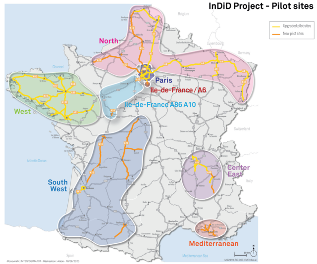
Building upon SCOOP@F, C-Roads France and InterCor, experimentations will be carried out on a broad part of the country, to encompass many configurations. Pilot sites are located in the Mediterranean area (Marseille urban node, surrounded bottlenecks, Mediterranean corridor), in the South West (Atlantic corridor, Bordeaux vicinities), in the Centre East (Mediterranean corridor, Grenoble urban node) and in the North (Paris, surroundings, North Sea and Atlantic corridors).
Experimentations will be carried out to prove that hybridisation of short-range (e.g. ITS-G5) and long-range (e.g. cellular) technologies is on the path toward large-scale deployment. Additionally, infrastructure digitalisation is a key step to enable enhanced perception and augmented mobility.
InDiD will upgrade Day 1 use cases, as defined by the C-ITS Platform, to improve their performance (e.g. event location). Implementation of new Day 1.5 use cases will address major stakes within French urban nodes (e.g. multimodality, intersections crossing). Besides, InDiD partners will experiment forthcoming Day 2 services related to enhanced perception for automated vehicles.
Strongly involved in the C-Roads Platform, InDiD initiative will bring together laboratory and closed experimentations with open road driving to assess interoperability impacts and deliver a mix of evidences on sustainability of EU strategy.
Location Description
InDiD aims at continuing the deployment of Cooperatives Intelligent Transport Systems on new road experimentation sites in order to expand the services coverage offered by the infrastructure.
Eight Pilot sites are located on four main French geographic areas, on the Mediterranean side, in the south-west area, at the center and in the north of France.
Beneficiaries
The project relies on a strong consortium, gathe¬ring a plurality of actors of Industry, Mobility and Digital. In total, 24 beneficiaries, coordinated by the Ministry of Transport, are involved including collectivities, interdepartmental road directorate, highway service companies and their representatives, academia and companies.
Implementing Bodies
Road operators:
- Ministry: public road operators (DIRs Méditérannée, Ile-de-France, Est, Centre-Ouest, Sud Ouest, Atlantique, Centre Est, Nord, Ouest)
- ASFA: concessionaries road operators (APRR, SANEF and VINCI Autoroutes)
Local authorities:
- Département de l‘Isère, Aix-Marseille Metropolis, Grenoble Metropolis, Ville de Paris
Universities and higher education and research institutions:
- Université Gustave Eiffel, Université de Reims Champagne-Ardenne, Bordeaux INP, Université Clermont Auvergne, Institut Mines-Télécom, Université Polytechnique Hauts de France,
- CEREMA, Eurecom, IGN, Vedecom,
- LAB (PSA, Renault)
Companies:
- Valeo,
- TomTom,
- IDNomic,
- Green communication,
- Transdev Autonomous Transport Systems,
- ATC France
Schedule
The project’s schedule follows the usual path: use case definition, specification, development, validation, deployment. Pilot sites are expected to be ready for driving by the end of 2022.
Map