Ireland

Description
Since 2019, Ireland has taken an active role in the implementation of the European Union Cooperative-Intelligent Transport Systems (C-ITS) strategy, upgrading its membership within C-Roads Platform to “Core” member along with other Member States.
This €10 million project is 50% funded by the European Union and was awarded and signed by Ireland in 2019, allowing Ireland to implement a national C-ITS Pilot. The overall aim of the C-Roads Ireland C-ITS pilot is to deploy, trial and evaluate current and future C-ITS services. The pilot includes development of services to align with Irish priorities, whilst recognising relevant standards and regulations. The pilot is testing and evaluating C-ITS services on the Irish Roads Network, predominantly on the Irish TEN-T network and also along urban corridors within Dublin City.
One of the earliest challenges encountered by the pilot design team was in relation to identifying suitable sites to deploy road-side units to achieve optimal ITS-G5 coverage. There were a number of factors considered, such as the identification of suitable existing or planned ITS infrastructure e.g. gantry sites, fibre access points, the performance of the road side unit and factors affecting signal propagation, e.g. topography, overbridges etc. Detailed radio modelling was undertaken to confirm and refine the design giving greater certainty on the location and reducing the number of sites required. The modelling analysis needs to be verified by site surveys, but early conclusions have indicated that fewer installations will be required to achieve optimal coverage than initially envisaged, significantly reducing civil infrastructure costs.
The C-ITS pilot is currently testing the developed solutions to ensure compliance with Industry standards and specifications and that the system operates as expected and provides all of the required use cases accurately.
Location Description
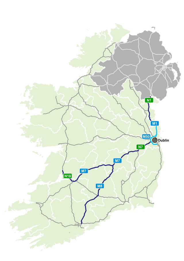
The pilot will cover 355 km of the Irish motorway network including the M50 around Dublin, the N7/M7 to Limerick in the West, the M8 to Cork in the South, and the M1 to the border North of Dundalk.
- M7, N7, M8, N1 – C-ITS services supported via cellular communications (dark blue on map)
- M50 and M1 – C-ITS services supported by a combination of cellular and ITS-G5 Road Side Units (RSU)s, providing direct digital communication between roadside infrastructure and vehicles (I2V) (light blue on map)
It is foreseen that the following in-vehicle equipment will be required:
- 150 vehicles equipped with ITS-G5 technology that are capable of vehicle to infrastructure (V2I), infrastructure to vehicle (I2V) and vehicle to vehicle communication (V2V)
- 10 vehicles equipped with C-V2X technology
- 1,000+ vehicles equipped with a C-ITS smartphone app
Beneficiaries
Transport Infrastructure Ireland is the Implementing Body.
Schedule
- 2019/23 – Planning, procurement and development of systems/solutions
- 2023/24 – Pilot deployment, operations and trials
- 2024 – Pilot evaluation and assessments, including planning for wider deploymen
ITS-G5 road side units will be deployed on sections of the M50 and M1 motorways. A total length of approximately 60km will be equipped with road side units.
Map