The Netherlands
Description
Rijkswaterstaat, in its role as the practical execution of the work of the Dutch Ministry of Infrastructure and the Environment is supporting the development and dissemination of innovative road solutions.
Based on the work on services for InterCor, The Netherlands will provide enhanced and extended test fields including strategic sections of the TEN-T Core Network, thus strengthening the efforts of the C-Roads community.
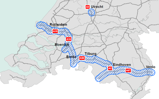
Pilot Area: The Dutch Corridor Area is situated in the south of the Netherlands. The area consists of the TEN-T Core Network road section from Europoort Rotterdam to the Belgian border, A15 A16. The section from Eindhoven to Venlo, A67. To connect these two Core network sections and have a meaning full ongoing corridor to roll out the proposed services, the road section Breda to Eindhoven (A58, A2) of the comprehensive network, has been added because of the major C-ITS developments which takes place there. Next to that also the Core network section on the A2 around the Leidsche Rijn Tunnel is added and also the section from the Belgian border to Eindhoven (A67) is added. The total network stretches out for 268km of which 60km or 22% is comprehensive network. Next to these road sections the port of Rotterdam, industrial and logistic area makes part of the Dutch corridor. Also the Moerdijk industrial area and the Venlo Trade Port are included. Both Rotterdam and Moerdijk are seaports on the core network. Venlo Trade Port is a multimodal platform on the CEF Corridor North Sea Mediterranean. To strengthen the corridor A58 and A67 in the Province of Noord Brabant, budgets have been allocated for innovative solutions. To improve the accessibility of the region “Smart Mobility” solutions will be piloted and implemented. Combining the Brabant Corridor initiatives with the services proposed within the InterCor project, the region will benefit even more.
Services: The day-one services Road Works Warning (RWW), Probe Vehicle Data ( PVD) and In Vehicle Signage (IVS) will be tested and implemented on the whole proposed Dutch Corridor Area. Also a parking information service for trucks will be tested and implemented. This service indicates positioning and free spaces at truck parking lots along to the whole Dutch Corridor Area. Tunnel management information use information from traffic management systems to communicate to logistic companies to optimize road usage through pre- and on trip information. Solutions can involve travelling at other times or using different routes. For logistics companies this can save a lot of time and for the road authority the result can be less congestion. Tunnel management service is based on Day-One services like In-Vehicle Signage and Road Works Warning, using the hybrid communication concept. A service focused on the optimization of the delivery of cargo goods will be studied and piloted near the port of Rotterdam, the industrial area of Moerdijk and the trade port of Venlo. This service, based on the Speeddocking concept2, is focused on multimodal cargo container loading and unloading optimization and cargo goods delivery planning. In order to reduce the built-in slack in delivery plannings, transport will follow the principle of just-in-time planning by various measures on the corridor such as dynamic speed advice, temporary parking and forecast waiting times. Reducing the slack will result in less buffering at nodes and roads and therefore a reduction in congestion, emissions and costs. This pilot site builds upon current deployment initiatives (with ITS equipment already operational or being installed): ITS corridor, eCoMove, Compass4D, Beter Benutten Program, DRIVEC2X, and FREILOT.
Location Description
The services will be piloted along the Dutch part of the Rhine-Alpine corridor, formed by the Dutch motorway A2, A58, A16 and A15 as well as along the A2 in the area of the city of Utrecht
Beneficiaries
The project coordinator is the Dutch Ministry of Infrastructure and the Environment; the daily management will be done by the Test site Project Management Team.
Furthermore Provincie Noord Brabant and Provincie Utrecht are involved.
Schedule
The project’s schedule follows the usual path: use case definition, specification, development, validation and evaluation, deployment. Pilot sites are expected to be ready for driving by the end of 2019, road shows are planned for 2020
The Dutch pilot activities needs to be seen in close cooperation with the Dutch work on InterCor, which is expected to have its pilots operational by mid 2019.
Key Performance Indicators
The main objectives of the Dutch pilot are the fulfilment of the Day-1 services, namely Probe Vehicle Data, Green Light Optimization (GLOSA), In Vehicle Signage and Road Works Warning.
The communication will be either G5 only, or hybrid - so separate G5 and cellular.
For freight services, important for InterCor, a cellular only solution will be established.
Map