C-Roads Cooperative Streets
Description
Cooperative Streets is aimed to pilot and pre-deploy C-ITS services in several urban areas along and feeding TEN-T transport network that will complement the scope of previous C-ITS projects (namely C-Roads), conducting rigorous, transparent, and replicable testing while addressing long term viability, cost-efficiency, governance models, business cases and overall impacts and benefits before moving towards large scale deployment to most urban areas, municipalities and cities in general, addressing multimodality and the urban expansion of C-Roads Portugal (CEF Action 2016-PT-TM-0259-S).
Cooperative Streets is aiming at fulfilling the following policy goals in road safety: reducing accidents and incidents; cohesion: bringing to the arena major urban areas along the core network; decarbonisation: promoting public transport use added value for citizens: mobility as a service solutions.
Cooperative Streets generic goal of building the digital transport data layer in Portugal establishes the Action's key principles: multimodality, interoperability, data sharing, data re-usage; static data as baseline and progress towards dynamic data; digitalisation of transport network (both physical and digital layer); preparing roads and streets for Day 2 C-ITS services.
The evolution of connected mobility towards urban and metropolitan areas will be accompanied by the necessary involvement of the National Access Point (NAP) and its governance structure. The NAP is a key feature for the entire process, and requires development into a central and transversal system that guarantees a data-sharing interoperable, seamless, functional, reliable and permanent communication tool.
The key objective of the Cooperative Streets project is to establish a pilot case for the evolution of the NAP, developing the necessary architecture, governance model and standards that will allow for integration of the different mobility systems and all the necessary stakeholders. The goals for an extended NAP are therefore common to all the Cooperative Streets pilot cases and represent a bridging activity for this project.
To deliver on the overall objective of the Action, there are 5 specific pilots.
- Pilot 1 - "Extended Multimodal National Access Point (NAP)" – the NAP has been initially developed for a road usage perspective, not fully adaptable to a multimodal and interoperable perspective. This pilot aims at testing and developing the better model for a transversal multimodal NAP.
- Pilot 2 - "From C-Roads to Cooperative Streets" - represents the connection between roads and the connection to urban nodes, namely urban highways.
- Pilot 3 - "Cooperative Streets" - aiming at the expansion of C-ITS from road to street environment, involving activities to test C-ITS for soft mobility, MaaS solutions, parking and traffic management, as well as on demand transport.
- Pilot 4 - "MMTIS" (Multimodal Travel Information Services) - covering the need to define a policy framework for both the public and private sectors that operate with the information value chain, and focusing on testing the specifications to properly monitor the performance of public transport contracts and their information systems – Data sharing Focus.
- Pilot 5 -"Urban test-bed - Zone to free test technology"- testing the implementation and necessary conditions to deploy these areas that are physical or intangible spaces that gather and replicate the real conditions for the development of demonstration and testing activities of technologies with different maturity states – Knowledge transfer Focus.
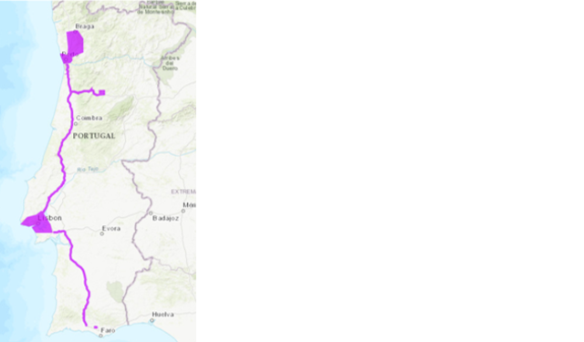
Together these macro pilot applications correspond to 60 pilot activities which will demonstrate the potential of C-ITS as a service continuity from roads to metropolitan and urban areas benefiting from already established and well-defined standards. The goal will be to build on the pre-existing services and conditions in order to achieve a swift deployment of C-ITS and preparation for connectivity and automation not only across the national core and comprehensive network (already in process with C-Roads Portugal), but also progressing into the two metropolitan areas of Lisbon and Porto and towards other municipalities along the axis between these two cities.
More Information: https://www.linkedin.com/company/cooperative-streets
Implementing Bodies
- Área Metropolitana do Porto;
- Associação Porto Digital.
- Associação TRANSPORLIS
- Associação para a Exploração e Gestão dos Serviços de Informação da Viagens Multimodais da Área Metropolitana de Lisboa;
- ARMIS – Sistemas de informação, Lda;
- BGI - Brisa Gestão de Infraestruturas;
- Brisa Concessão Rodoviária, SA (BCR);
- Câmara Municipal de Cascais;
- Câmara Municipal de Gondomar;
- Câmara Municipal de Lisboa;
- Câmara Municipal de Loulé;
- Câmara Municipal de Matosinhos;
- Câmara Municipal de Santo Tirso;
- Câmara Municipal de Valongo;
- Câmara Municipal de Vila Nova de Gaia;
- Câmara Municipal de Viseu;
- Câmara Municipal do Porto;
- CEiiA - Centro de Engenharia e Desenvolvimento;
- Companhia Carris de Ferro de Lisboa, E.M., S.A.;
- EMEL – Empresa Pública Municipal de Estacionamento de Lisboa, E.E.M.;
- GMVIS Skysoft, S.A.;
- Infraestruturas de Portugal, I.P.;
- Instituto da Mobilidade e dos Transportes, I.P. (IMT, I.P.);
- ISEL - Instituto Superior de Engenharia de Lisboa;
- Loulé Concelho Global, E.M.;
- MIH – Município da Trofa;
- Município de Lousada;
- Quadrilátero - Associação de Municípios de Fins Específicos Quadrilátero Urbano;
- Siemens Mobility, Unipessoal Lda;
- TISPT - Consultores em Transportes, Inovação e Sistemas S.A.;
- Via Verde Serviços (VVS);
Key Performance Indicators
Through Cooperative Streets, C-ITS services will implemented along 210 km of roads leading to urban nodes, ensuring a continuity of service along the core network and well into Lisboa and Porto municipalities. In total more than 500 RSU will be installed with more than 800 OBU and 800 vehicles in operation by the end of the action. Together with this, 17 cities will display multimodal travel information through the NAP.
Map