C-ITS roadside units in the TENtec interactive map
The location of operative roadside C-ITS stations all over Europe is now available in the interactive map viewer operated by the European Commission. This marks an important milestone for improving the public perception and visibility of C-ITS services in the course of the ongoing transition from roll-out to live operation of cooperative services. The large number of operative roadside stations and their broad distribution is yet another proof of success of the harmonised approach pursued by the C-Roads Platform and all its pilot sites.
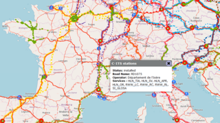
Cooperative services via ITS-G5 short range communication are existing and operational on European roads. The interactive map viewer shows all existing and operational infrastructure, which has already been installed in the field and which is compliant with the C-Roads specifications. In detail, the map provides information on the status, road name, the road operator and the C-ITS services covered. The displayed C-ITS stations are based on the information provided by the respective road operator via the members of the C-Roads Platform and will be updated on a quarterly basis. The location of the C-ITS stations as well as their development, operation and maintenance is under responsibility of the single road operator.
The comprehensive availability of C-ITS stations underlines the importance and practical relevance of the short-range ITS G5 approach as counterpart to long-range cellular communication in the scope of a hybrid communication approach as given by the harmonised communication profile of C-Roads. It is evident that C-ITS has successfully started to manifest in daily driving and is on the verge of bearing fruit with regards to a European harmonised approach for more road safety and efficiency.
Explore the map here (Layers --> C-ITS stations).
Request the harmonised communication profile here.